Fishing on Arresø |
 |
Fishing is permitted on Arresoe. You can fish from places where there is legal public access and from a boat. Wide zone must not be controlled.
For fishing from ice, special rules apply.
All anglers who are 18 - 65 years old must have a fishing sign. Fishing sign can be purchased online, read more about this at The Norwegian Fisheries Directorate's website
Commercial use is mainly related to considerable commercial fishing, where eel and sand species are the most economically important fish species, but the utilization of the pipe cut and the use of the lake's runoff to cooling water also have some significance. The lake is designated by the conservation authorities as a national biological area of interest and, furthermore, as a Community bird protection area.
However, the ecological status of the lake is not good. As a result of wastewater supply from, in particular, Lyngby Å, Æbelholt Å and Pøleåen, the lake is heavily nitrogen and phosphorus-laden. The City Council's recipient surveys 1976-81 clearly showed the deteriorating balance, which can only be improved by extensive wastewater treatment.
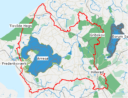
Arresoe borders on four municipalities
(Frederiksvaerk,
Helsinge,
Hilleroed and
Skaevinge). Arresoe has drains to Roskilde Fjord through the Arresoe Canal in
Frederiksvaerk.
There are a large number of runs to Arresoe, of which
Pøleå is the most significant. Especially along Arresø's west side there are several hillsides (eg Maglehøj at Frederiksvaerk and Arrenakke Bakker), from which there is a magnificent view of the lake. East for
Frederiksværk stretching the peninsula
Arrenaes out into Arresoe.
Fiskeri
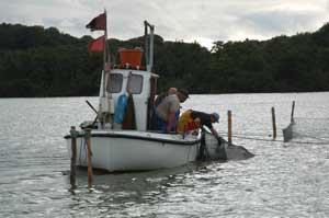
Lake Arresoe has a large population of skull, bream, sand and eel. Other fish include pike, perch, lion, skull and hork. Sandarten, which was postponed in 1927, is a very fine fish. It is known to have a very fluctuating stock size. 1996 and 1997 were extremely good breeding years for the sand species. The fish has now grown large, and in 2001 it was estimated that 24% of the fish mass consisted of sand species, only surpassed by shells and bream. There are few of the natural predatory pike and perch, as they do poorly in the opaque water. The fishing is rented out for commercial fishing, and in addition to sand species and dirt fish (bream etc.), a lot of eel is caught.
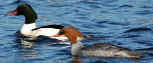
Bird life on Arresoe
Stor
bald he and she
|
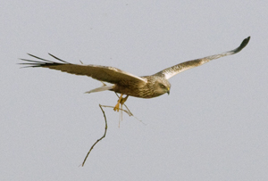
Rørhøg med redemateriale. |
The bird life is strongly influenced by the pollution. There are only a few swans. These live on bottom plants, but there are not many of them on the dark sea bed, which the algae prevent sunlight from penetrating. On the other hand, many seagulls, herons, cormorants and if you are lucky osprey are seen.
In the wide zone, there is a very rich but often hidden bird life with geese, ducks, haystacks, tubing rooms, and canopy. In the spring, the cuckoo is heard, and in the autumn large flocks of swallows and starlings, who spend the night in the roofing pipes.
Arresø is a Community bird protection area for breeding tubing, pipe hawks and osprey, as well as too large shell gulls as a draft guest.
Sea eagle in 2009 settled in Nejede Vesterskov. It is now seen daily hunting over Arresø.
.
In 2011, the Nature Agency has built a long wooden bridge through otherwise impassable ellesump and tubing for a viewing platform on the edge of Arresoe.
Habitat area 
Arresoe is designated as an EU habitat area and EC bird protection area. Read more about Natura 2000 on the Danish Nature Agency's website. Here you will also find the basis of designation for Arresø etc.
Bathing
Bathing bans have been issued for the entire Arresø
See Hilleroed Municipality's website on bathing water.
Avderoed peninsula, Arrenaes |
 |
Arresoe inland is plotted with red, the runoff is through the Canal in
Frederiksvaerk
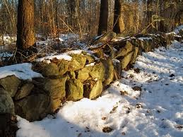
The Avderoed peninsula, called Arrenaes, extends from the county road Hillerød - Frederiksvaerk into the country's largest lake, Arresø. The area around Arresø is characterized by a number of different landscape formations, several of which are rare in Eastern Denmark, both in terms of frequency and extent.
Most of the surrounding land areas are made up of last-ice moraine landscapes, but in addition there are widespread post-formation formations that result from land uplift, sea rise, water and wind erosion as well as sea and freshwater deposits, etc.
Central and Southern part of the peninsula consists of a high-lying, partly hilly terrain with the highest point Maglehøj, 70 m oh, while the northern part consists of a lower-lying, evenly hilly terrain with the highest point Lille Maglehøj, 27 mh
 The peninsula, moreover, appears as a hilly agricultural land with great landscape variation, caused by an interaction between cultivated fields, pastures, forests, small gardens, hedgerows and meadows and wetlands. Soil conditions vary greatly. The best agricultural land is found on the northern part, while the light land dominates. Of larger forests there are Auderød Forest (72 ha) and Sonnerup Forest (61 ha) - both predominantly deciduous forests.
The area is associated with considerable scientific and historical interests. A number of sites are of particular biological interest, especially the wetlands Nørremosen and Dronningholm bog as well as the entire sea bream. There is thus a rich plant life with several rare species, and the whole area with the lake is of great importance as breeding and resting place for a large number of swimming and wading birds.
On the peninsula there are 12 protected bronze age hills, several of which Due to their location at highlights, the landscape is very dominant. The Dronningholm riots contain excavated ruins from a royal castle, which for several centuries has served as the seat of a sheriff. The castle built in the Middle Ages is thought to be demolished in the 16th century, and the ruins have recently been restored.
Already in 1945, the majority of the peninsula was imposed on a registered rescue plan, which, however, was abolished by the Nature Conservation Act in 1975 . in the years before, the State had, with a view to securing the most valuable areas, begun buying properties; first purchase in 1967, and in the period up to 1976, 8 agricultural properties and some small areas were acquired with a total area of 254 ha. From 1976, the administration has been placed under Tisvilde State Forest District, which incl. the 2 forests manage 387 hectares of the peninsula's approx. 860 ha.
The cultivated agricultural areas are all rented out to local farmers, while the buildings are rented out for various purposes, among other things. Scout center (Ellehavegård), riding center (Fuglsanggård). In 1977, the conservation plan committee for the Copenhagen, Frederiksborg and Roskilde counties issued a "Proposal for landscape conservation and recreational use", which has formed the basis for the previous administration of the area.
Arrival River Destination
The lake, which has a surface area of 40.7 km2, is also owned by the Ministry of the Environment and Energy at Tisvilde State Forest District. In the Stone Age, both Arresø and Roskilde fjord appeared as wide, shallow waterside, separated by a ridge with Arrenakke as the extreme nose, but later landslides blocked the connection to the Kattegat. A violent sand escape in the 15th and 17th centuries further cut off the lake's natural drainage to Roskilde Fjord, and in 1717-19 a canal was dug to the fjord at Arresødal, around which Frederiksværk town originated.
& nbsp;
The lake's water depth is modest; on average 3 m and not more than 6 m, and as a result of a high concentration of plankton algae (green algae) a very low depth of sight; on average 30-40 cm. A tubular forest consisting of roof pipes and down hammer occurs almost everywhere and covers approx. 7% of the lake area. Arresø is of great business, conservation and recreational importance.
Shooting field
The Naval Academy's primary school had some shooting ranges south of Auderød Forest until the school moved to Frederikshavn, the danger area stretching far beyond Arresø. When shooting, there was no traffic in the danger area. The shooting range is closed and the marking has now been removed.
Arresoedal Bridge |
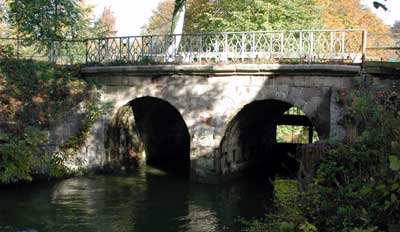 |
The water level in Lake Arresoe for summer and winter respectively was originally adopted in 1832 and carved into the Arresødal bridge. The river target mark is approx. 4.27 meters above sea level.
During the winter months, the water did not have to rise above it, in the summer half of May to 1 October it should stand 12 "below.
The Arctic Red Bridge , this is the lake's water level is regulated
The current water level is determined by a land commission commission order October 4, 1977 in connection with the rebuilding of the existing lock at the bridge. i> It can also be stated that the sluice will be arranged with a maximum opening height of 2.05m, corresponding to 0.62m above the winter river target, queue 4.28m odnn
During the maneuvering of the lock system, consideration will be given to the Ministry of Agriculture's recommendation of 3 July 1962, that the water mirror of the Arresøe should not exceed the cut 3.97m and so on.
When the water level in Arresø is over 3.97 DNN (equivalent to 3.90 DVR90) at the Arresød valley bridge, the locks are always completely open.
History
In the Stone Age, Arresoe was a shallow fjord that also included the surrounding bogs Ryeng, Ellemosen and Lille Lyngby Mose etc.
Through a narrow channel over the Sand, Karsemosen and Melby Overdrev stood the fjord in connection with the Kattegat.
At beach ramparts and land reclamation, the fjord was gradually blocked from the sea and became a freshwater lake with drains along Arrenakke Å to Roskilde Fjord.
Arresø is the actual foundation for Frederiksværk, which became Denmark's first real industrial city. In the 17th century, the old drains sank, and after several floods in 1703 to 1714, the current canal was dug from Arresoe to Roskilde Fjord. It was finished in 1719 and secured a stable water level in Arresø. In 1728, one saw the possibility of exploiting hydropower. A poll was made and an agate grinder was built. The industry developed among other things. for the manufacture of guns and gunpowder. Today Arresø delivers the cooling water to The Danish Steel Rolling Mill.
Dronningholm Borgruin is located on Arrenaes overlooking Vinderød Church
Dronningholm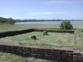
Dronningholm was built around the year 1200. It was built on an islet, surrounded by a water moat and ring ramp. You must imagine Arresø back then was somewhat larger than today.
Valdemar Atterdag put various sheriffs on the castle and much later Queen Margrete took over the castle. From 1520 Archbishop Gustav Trolle sat on the castle. He refused to renounce the castle when Frederik I came to power. This resulted in an armed takeover, but unfortunately the castle was then allowed to decay.
The barn yard was located approx. 200 m northeast of the castle on land.
In 1933-39, the National Museum excavated the remains of Dronningholm and this detail from one of the walls appeared.
Water quality
The industrialization and introduction of the water-rinsing lavatories around 1920 was a serious burden for Arresø, but only in the 1950s did it really go wrong. For half a century Arresø received the wastewater from the neighboring municipalities Helsinge, Hillerød, Frederiksværk and Skævinge, and Arresø is today one of the country's most polluted lakes.
Due to a high nutrient concentration, the algae amount is very large, which gives the water a characteristic muddy green color with very little sieve depth (20-40 cm). Since 1989, Arresø has been examined annually as part of the national monitoring program. In 2002, Arresø did not meet the target, even though the condition has improved in recent years. The reason why Arresø is better off is primarily that previous massive pollution with waste water from the cities has been significantly reduced through the expansion of the municipal wastewater treatment plants. Likewise, in the hinterland of Arresø, demands have been made on the wastewater treatment on individual properties and four out of five planned lakes or wetlands have been established in the hinterland to retain phosphorus.
Outdoor life
If you want to experience Arresø from land, we can recommend a hike on Arrenæs, in Avderød Forest or Sonnerup Forest. The hiking folder for Arrenæs is a little outdated, but the map is good enough.
On the east side of Arresø a hike from Ll. Lyngby to the mountain at Ll. Lyngby bog or a trip on Hovgårdspynt good nature experiences with the opportunity to experience the bird life. In winter, eagles are often seen over Arresø.
There is still no hike all the way around Arresø, but work is done on the matter.
Bathing is prohibited as it can be associated with health hazards due to the many algae.
.
Outdoor facilities along Lake Arresoe
On the Udinaturen.dk you can find an overview over Outdoor facilities at Arresø
Sailing
Passage by rowboats, sailboats and other vessels operated without motor power is permitted.
Canoeing and kayaking and sailing with windsurfers are not allowed during the period March 1 - July 1.
For the sake of bird life, kite surfing is not permitted.
Sailing on Pøleåen is permitted during the period 15 July - 1 April, but only below Solbjerg Engsø. There is often shallow so grounding will occur. The tour is not suitable for groups. Alsønderup Engsø is home to a rich bird life and many birdwatchers use the bird tower here, so avoid sailing around the Lake Engsø.
Motor boat sailing with certain exceptions is not permitted on Arresø, see Rules for traffic etc. on Arresø.
In winter, the lake's ice-covered surface is very popular for ice-boat sailing and ice-skating.
See clips from 2nd start in DM in ice boat sailing 2010
All sailing must be based on those sites approved by the Danish Nature Agency - North Zealand.
Frederiksværk Camping and Youth Hostel rents canoes and kayaks on hour, day and week basis. From here you can sail through the Canal to Arresø. Tel. 47 77 07 25
There is a marina in Ramløse where Arresø Sailing Club is there.
It has again been allowed to sail on the canal through Frederiksværk. There are sledding trails, so today it is possible to sail in a canoe or kayak from Roskilde fjord to Arresø. You can also put the canoes directly in Arresø.
Canoeing and kayaking trips and windsurfing are not permitted during the period March 1 - July 1.
.
.
The Maritime Council must try to coordinate the many different user interests associated with Arresø and be Advisory to the Danish Forest and Nature Agency, North Zealand regarding the operation and use of Arresø.